The core position of GPS in modern precision agriculture is reflected in all aspects, such as providing real-time and accurate positioning information and navigation information for agricultural machinery.
Modern precision agriculture is inseparable from GPS navigation and positioning system.With the development of precision agriculture towards high precision, GPS navigation and positioning system is more widely used, and gradually plays a leading role in modern agriculture.In the early 1980s, some universities and research institutes began to study GPS technology, and established permanent GPS tracking stations in Beijing, wuhan, Shanghai, xi 'an, Lhasa and urumqi, etc. for precise orbit orientation of GPS satellites, so as to provide observation data and accurate ephemeris service for high-precision GPS positioning measurement. At the same time, China has started to build its own satellite navigation system (binary star positioning system), which can produce navigation GPS receiver. The application of GPS technology is moving into deeper level, and the application of GPS technology in agriculture is also improving day by day. However, the development of GPS navigation technology still has some problems, such as difficulties, great high-tech proportion, limited research funds and low profits of the industry. There are many problems in the application of GPS navigation technology for domestic agricultural vehicles, mainly due to the single vehicle type, incomplete functions and poor quality of vehicles developed in the industry. Many equipment still rely on importation, but most rural users in China cannot accept such high procurement costs. What we need to do is to realize the localization of foreign GPS products.
Inner Mongolia Kaiyuan Technology Co. LTD. a member of Beiwulian Smart Agriculture Industry Alliance, is a sino-Italian joint venture, which mainly engaged in the production and sales of agricultural GPS products, related technical consulting, technical services, and land leveling and construction. Recently, at the 7th China intelligent agriculture innovation development summit BBS and "craftsman agriculture cup" award ceremony, Inner Mongolia Kaiyuan Science and Technology Co. LTD won the prize, Ms. Chi Lanying delivered a speech at the meeting as a representative of the winning company and introduced some products and business.
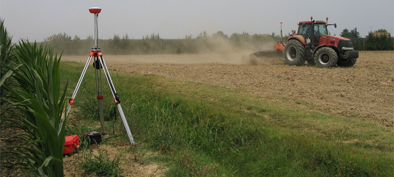
First, the GPS leveling instrument products, this product is the strategic product of Kaiyuan technology, it is independently researched and developed by the Italian company, producted by our joint venture company. The working accuracy of this product is plus or minus 2 to 3 centimeters, and there is no similar product in the domestic market. The products are mainly used for land reclamation, land leveling, drainage system design, etc., and are very important for the cultivation of crops such as cotton, corn and rice. They can be installed in tractors, bulldozers, excavators and other agricultural machinery.Compared with the laser levelling instrument used in the current market, the working efficiency of the GPS levelling product of Kaiyuan Technology is improved by 50%. Flagship products of the leveling series LL2, especially used for leveling rice fields. The rest products can be used to smooth slopes or build roads. Leveling products used to build roads do not have similar products in China.
Second, GPS automatic navigation series products, which are widely used in agricultural work, can realize the automatic driving, and the precision control of our products in the range of plus or minus 2-2.5 cm, The large area crop cultivation efficiency is very high, used in a variety of crop planting, harvesting, watering, reclaiming, etc. Kaiyuan Technology's autonomous driving product have three more models than similar products on the market, namely: ES2, ST20 and ST60, which can be installed on tractors, sprayers and trenchers of various brands at home and abroad.
Third, GPS mu meter, which is mainly used for land survey, mapping data and land planning, etc. It can accurately measure the land data. Models are: K50, K100, K900.
KAIYUAN technology products have three advantages:
First, price advantage.Kaiyuan Technology introduces foreign advanced technology and produces in China, while the raw materials are supplied by Chinese suppliers, which reduces many costs compared with the imported ones. This is the advantage in price.
Second, technological advantages.The Italian company has strong technical capability and a strong research and development team, which can continuously deliver new products, new software and new product upgrade technologies.
Third, localization advantage.We have introduced all technologies and production lines such as software of Italian GPSkit company and SCS company. The localization of products highlights the price advantage.
At present, domestic clients respond well to Kaiyuan Technology products. This year, Kaiyuan Technology completed a land leveling project in xinjiang with its own products and solutions. The project is from survey, land planning, layout design to land leveling construction, all use their own products, personnel and solutions. The client experience the advantage of saving time, effort and money in the process of using the product.


Land leveling of GPS in Inner Mongolia Inner Mongolia agricultural equipment